In October 2020, a campfire ignited a bushfire near the north end of Australia’s Fraser Island. Over the course of two months, the fire spread widely, scorching half of the World Heritage Site and threatening local wildlife.
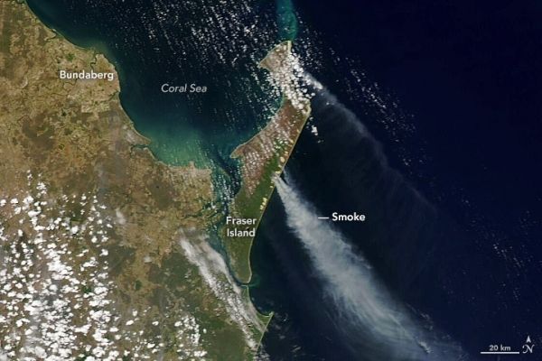
The images above show Fraser Island in early December 2020. The false-color image (left) shows the burn scar on December 5 as observed by the Moderate Resolution Imaging Spectroradiometer (MODIS) on NASA’s Terra satellite. The false-color image uses a combination of visible and infrared light (MODIS bands 7,2,1) to better distinguish the burn scars. Burned vegetation appears brown or deep orange and unburned vegetation appears bright green. The natural-color image (right) shows smoke plumes rising from the eastern side of the island on December 7, as observed by MODIS on board NASA’s Aqua satellite.
Spanning 180,000 hectares (440,000 acres), Fraser Island (also called K’gari) is known for its tropical rainforests, sand dunes, and inland lakes. It is home to wild dingoes and several rare plant species. It is also the world’s largest sand island with over 250 kilometers (160 miles) of sandy beaches and more than 40 kilometers (25 miles) of sand cliffs. About 100 people live on the island, though hundreds of thousands of tourists visit the beaches each year.
Continue reading at NASA Earth Observatory
Image via NASA Earth Observatory