For the second year in a row, drought has parched much of the United States from the Rocky Mountains to the Pacific Coast. Following one of the planet’s warmest years on record, and with precipitation this year well below average in the western U.S., scientists and government agencies are watching for diminished water resources and potentially severe fire seasons.
According to the June 10 report from the U.S. Drought Monitor, 88.5 percent of the land area in the West—defined as California, Nevada, Arizona, New Mexico, Utah, Idaho, Montana, Oregon, and Washington—is experiencing some level of drought, with 55 percent being classified as “extreme.” An estimated 90 percent of Utah is under extreme drought conditions, with 64 percent rated “exceptional” (the worst classification). Similar conditions are reported across Arizona (87 percent extreme), California (85 percent), and Nevada (76 percent). More than 58 million people are living with the dry conditions in the region.
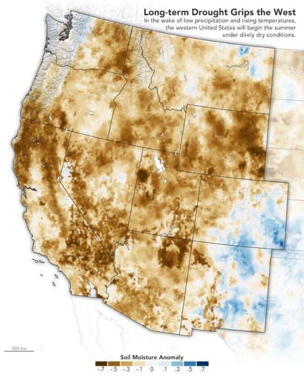
The map above offers one indicator of the conditions on June 5, 2021. Using data from the Crop Condition and Soil Moisture Analytics (Crop-CASMA) product, the map shows soil moisture anomalies, or how the water content in the top meter (3 feet) of soil compares to normal conditions for the time of year. Crop-CASMA integrates measurements from NASA’s Soil Moisture Active Passive (SMAP) satellite and vegetation indices from the Moderate Resolution Imaging Spectroradiometer (MODIS) instruments on NASA’s Terra and Aqua satellites.
Continue reading at NASA Earth Observatory
Image via NASA Earth Observatory