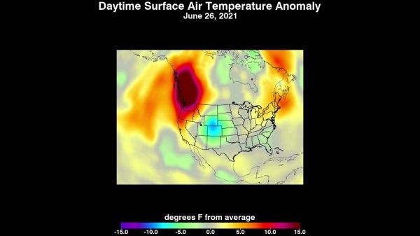
An unprecedented heat wave that started around June 26 smashed numerous all-time temperature records in the Pacific Northwest and western Canada. NASA’s Atmospheric Infrared Sounder (AIRS), aboard the Aqua satellite, captured the progression of this slow-moving heat dome across the region from June 21 to 30.
An animation of some of the AIRS data show surface air temperature anomalies – values above or below long-term averages. Surface air temperature is something that people directly feel when they are outside.
In many cases, the highs exceeded previous temperature records by several degrees or more. On June 28, Quillayute, Washington, set an all-time high temperature record of 110 degrees Fahrenheit (43 degrees Celsius), shattering the old record of 99 degrees Fahrenheit (37 degrees Celsius). Numerous weather stations broke records on consecutive days, showing the unprecedented nature of this extreme heat, which is also being blamed for a number of fatalities. In British Columbia, the village of Lytton set a new all-time record for Canada at 119 degrees Fahrenheit (48 degrees Celsius) on June 29, only to break it the next day with a reading of 121 degrees Fahrenheit (49 degrees Celsius).
Continue reading at NASA Jet Propulsion Laboratory
Image via NASA Jet Propulsion Laboratory