Atlantic hurricanes don’t just come and go. They leave clues to their passage through the landscape that last centuries or more. Rice University scientists are using these natural archives to find signs of storms hundreds of years before satellites allowed us to watch them in real time.
Postdoctoral fellow Elizabeth Wallace, a paleotempestologist who joined the lab of Rice climate scientist Sylvia Dee this year, is building upon techniques that reveal the frequency of hurricanes in the Atlantic basin over millennia.
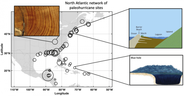
Paleoclimate hurricane data (or ‘proxy’ data) is found in archives like tree rings that retain signs of short-term flooding, sediments in blue holes (marine caverns) and coastal ponds that preserve evidence of sand washed inland by storm surges. These natural archives give researchers a rough idea of when and where hurricanes have come ashore.
Read more at: Rice University
The North Atlantic network of sites that preserve records of hurricanes stretches along the coast from Canada to Central America, but with significant gaps. A new study led by scientists at Rice University shows filling those gaps with data from the mid-Atlantic states will help improve the historical record of storms over the past several thousand years and could aid in predictions of future storms in a time of climate change. (Photo Credit: Elizabeth Wallace)


