A new method for detecting tsunamis using existing GPS satellites orbiting Earth could serve as an effective warning system for countries worldwide, according to a new study by an international team led by UCL researchers.
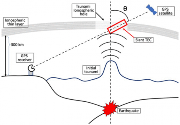
Initial tsunami waves are typically a few centimetres high but nonetheless cause a disturbance in the Earth’s upper atmosphere by pushing up air and creating an acoustic wave that is amplified as it goes higher.
This leads to a change in the ionosphere, 300km above the surface of the Earth, in which the density of electrons in the area is reduced. This in turn affects radio signals sent by GPS satellites to GPS receivers on the ground, delaying or speeding up different parts of the signal, or changing the signal’s direction, depending on frequency.
For the new study, published in Natural Hazards and Earth System Sciences, researchers from UCL and universities in Japan developed a new way to detect this dip in electron density from the altered GPS signals.
Read more at University College London
Image: Graphic illustrating concept of detecting tsunamis using GPS satellites (Credit: Ryuichi Kanai et al / Natural Hazards and Earth System Sciences)