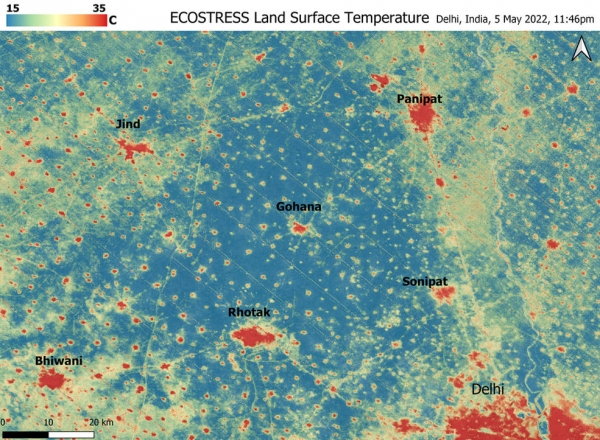
A relentless heat wave has blanketed India and Pakistan since mid-March, causing dozens of deaths, fires, increased air pollution, and reduced crop yields. Weather forecasts show no prospect of relief any time soon. NASA’s Ecosystem Spaceborne Thermal Radiometer Experiment on Space Station instrument (ECOSTRESS) has been measuring these temperatures from space, at the highest spatial resolution of any satellite instrument.
This image, taken shortly before local midnight on May 5, shows urban areas and agricultural lands northwest of Delhi (the large red area in the lower right) that are home to about 28 million people. The image covers about 4,800 square miles (12,350 square kilometers).
Cities are usually markedly warmer than the surrounding countryside due to human activities and the materials used in the built environment. The image clearly delineates these urban “heat islands.” Nighttime temperatures in Delhi and several smaller villages were above 95 degrees Fahrenheit (35 degrees Celsius), peaking at about 102 degrees F (39 degrees C), while the rural fields nearby had cooled to around 60 degrees F (15 degrees C). This data suggests that city dwellers are experiencing considerably higher temperatures than the average temperatures reported for their regions.
Continue reading at NASA Jet Propulsion Laboratory
Image via NASA Jet Propulsion Laboratory


