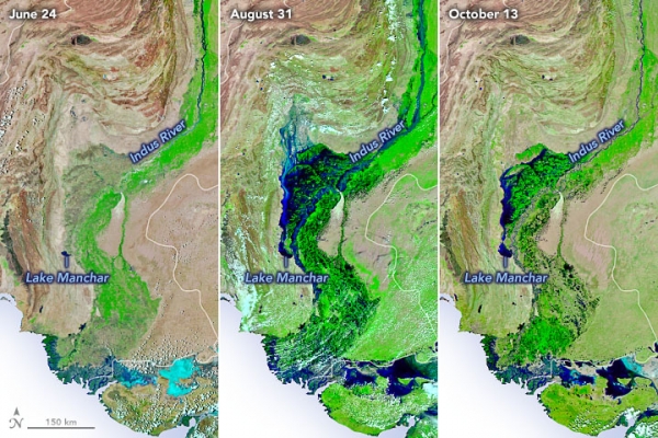
In early September 2022, floods in Pakistan were the worst in a decade. Monsoon rains had pummeled the region for several weeks and floodwaters inundated 75,000 square kilometers of the country. Six weeks later, rains have ceased, and fields have begun to drain. But vast swaths of farmland remain waterlogged, infectious diseases are spreading, and food shortages loom.
The images above show the progression of the flooding. The second image shows Sindh province on August 31, 2022, near the peak of the flooding. By October 13, 2022 (third image), a considerable amount of water had drained off the landscape and back into rivers. But many areas remained wet and waterlogged in comparison to June 2022 (first image). All three images were acquired by the Visible Infrared Imaging Radiometer Suite (VIIRS) on the NOAA-20 satellite. They are false-color images based on VIIRS observations of shortwave infrared and visible light, a combination that makes it easier to distinguish between water (blue) and land (green).
Rains in September 2022 were modest. Rather, the flooding visible in these images was caused by the arrival of torrential monsoon rains that hit southern Pakistan in July and August. (The rains were likely made more intense by climate change, according to the World Weather Attribution Initiative.)
Read more at: NASA Earth Observatory
Water has begun to recede, but large swaths of farmland remain waterlogged as food shortages loom and waterborne diseases spread. (Photo Credit: NASA Earth Observatory)


