Climate models are powerful tools that scientists use to study how the climate system works now and how it will change in the future under different scenarios of global warming. When models are updated with new scientific information, they must be evaluated to see how well they represent different climate features, including weather patterns found in particular geographical regions.
A new study led by Graham Taylor, a PhD student in Portland State's Earth, Environment, and Society program and Paul Loikith, associate professor of geography at PSU, tested how well climate models represent large-scale weather patterns over the Pacific Northwest. Researchers from Oregon State University and the Jet Propulsion Laboratory also contributed to the study, which was published in the journal Climate Dynamics.
“These complex computer models that simulate the Earth system can be thought of as virtual laboratories for climate science experimentation,” says Loikith. “If the models can't reproduce important features of the observed climate, they will not be very useful for studying the future climate.”
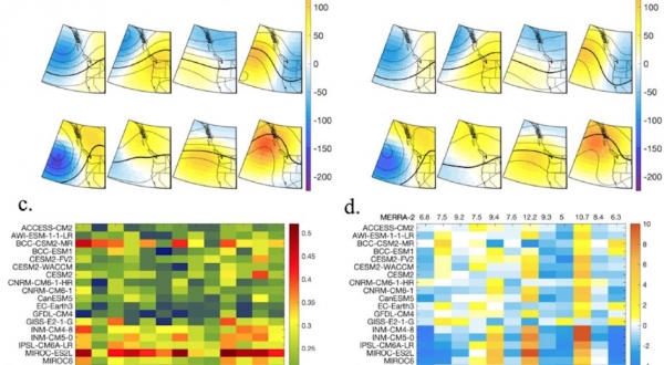
Since all computer models have different strengths and weaknesses based on differences in physics, scientists often use the output from many different climate models to assess projections of future climate change. For this study, the researchers used data from the state-of-the-art sixth phase of the Coupled Model Intercomparison Project (CMIP6) to test how well 26 different climate models could simulate the range of large-scale patterns of atmospheric circulation (like wind and pressure) found over the Pacific Northwest. These patterns range from those associated with warm and dry weather, to cold and stormy and everything in between.
Read more at Portland State University
Image: Climate model analysis (Credit: Paul Loikith)