According to a new NASA-led study, the world has lost 561 square miles (1,453 square kilometers) of salt marshes over the past 20 years. In a recent research paper, scientists described the first consistent global accounting of salt marsh locations and changes. The work also allowed them to start estimating the amount of carbon dioxide — a greenhouse gas — emitted into the atmosphere as marshland is degraded or lost.
Salt marshes are coastal grasslands that are regularly flooded by salty seawater, and they are both an indicator of and protector against climate change. They buffer coastal communities from severe storm impacts and rising sea levels. They provide vital habitat and nurseries for coastal plant, animal, and bird species, and recreation areas for humans. Furthermore, marshes sequester carbon in their vegetation, peaty muds, and other organic debris.
“Salt marshes store a significant amount of carbon, and as that carbon is emitted into the atmosphere due to wetland degradation, it propels climate change forward,” said Anthony Campbell, the study’s lead author and an assistant scientist in NASA’s Postdoctoral Program Fellowship. “Prior to this, we didn’t have maps of how and where marshes are changing. This study gives us an idea of how much carbon was emitted in the past 20 years.”
Read more at NASA
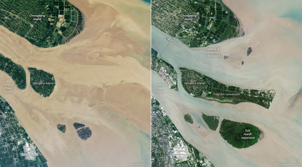
Image: Two satellite images of the Yangtze River Delta, taken by Landsat 7 in August 2000, left, and Landsat 9 in August 2022, right. The images show development in the area as well as changes in the salt marshes, which are impacted by climate and anthropogenic effects. (Credits: NASA Earth Observatory/Lauren Dauphin, using Landsat data from the U.S. Geological Survey)