Two California lakes, both drained a century ago, have been partially refilled by floodwaters from recent storms, satellite images from NASA show.
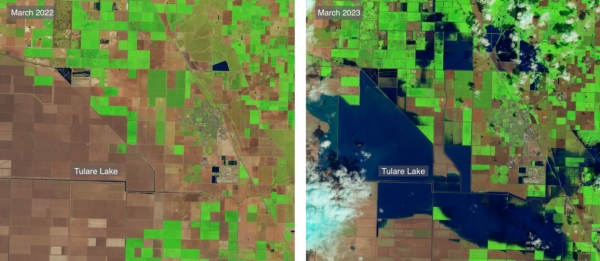
Tulare Lake in California’s Central Valley was once fed by rain and snowmelt from the western Sierra Nevadas, but a system of dams and canals erected in the early 20th century diverted water away from the lake to supply regional farms. Once the largest freshwater lake in the West, Tulare withered, and farmers planted cotton, tomatoes, pistachios, almonds, and other crops in the dried lakebed.
Owens Lake, which lies on the eastern side of the Sierra Nevadas, was also long fed by streams flowing from the mountains. But the 1913 construction of the Los Angeles Aqueduct redirected much of that water to Los Angeles, desiccating the lake.
In March, successive atmospheric rivers hit California, with the resulting floodwaters inundating farmland in the footprint of Tulare Lake. Near Owens Lake, severe floods eroded soil around the Los Angeles Aqueduct, leading to its partial collapse. Officials opened spill gates on the aqueduct to drain the damaged areas, allowing floodwaters to pour into Owens Lake.
Read more at Yale Environment 360
Image: The footprint of Tulare Lake in March 2022 and March 2023, after floodwaters inundated the area. (Credit: YALE ENVIRONMENT 360 / NASA)