Built on opposite sides of the planet, the NISAR satellite will deepen understanding of climate change, deforestation, glacier melt, volcanoes, earthquakes, and more.
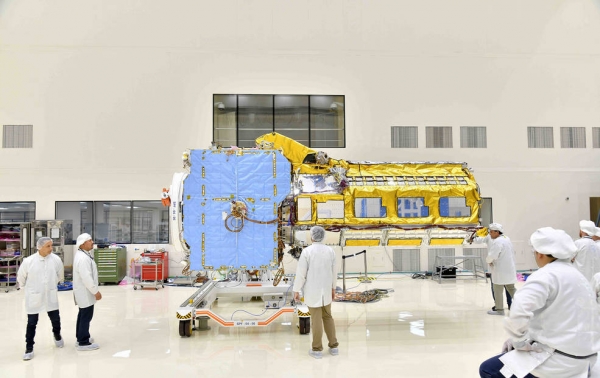
Two major components of the NISAR satellite have been combined to create a single spacecraft in Bengaluru, India. Set to launch in early 2024, NISAR – short for NASA-ISRO Synthetic Aperture Radar – is being jointly developed by NASA and the Indian Space Research Organisation, or ISRO, to track movements of Earth’s land and ice surfaces in extremely fine detail. As NISAR monitors nearly every part of our planet at least once every 12 days, the satellite will also help scientists understand, among other observables, the dynamics of forests, wetlands, and agricultural lands.
About the size of an SUV and partially wrapped in gold-colored thermal blanketing, the satellite’s cylindrical radar instrument payload contains two radar systems. The S-band radar is particularly useful for monitoring crop structure and the roughness of land and ice surfaces, while the L-band instrument can penetrate denser forest canopies to study the woody trunks of trees, among other observables. The wavelengths of the S-band and L-band signals are about 4 inches (10 centimeters) and 10 inches (25 centimeters), respectively, and both sensors can see through clouds and collect data day and night.
Read more at NASA
Image: Engineers joined the two main components of NISAR – the spacecraft bus and the radar instrument payload – in an ISRO clean room in Bengaluru, India, in June. The payload arrived from NASA’s Jet Propulsion Laboratory in Southern California in March, while the bus was built at the ISRO facility. (Credits: VDOS-URSC)