With nearly 170 million residents, Bangladesh is one of the most densely populated nations in the world. Nearly half of its residents work on or live around farms, and rice crops are critical to feeding that population.
So when researchers from the University of Washington and Bangladesh’s Ministry of Agriculture joined forces to use data from NASA and its partners to help the country’s rice farmers, the potential benefit was substantial. Through their IRAS program, short for the Integrated Rice Advisory System, researchers from UW and Bangladesh use satellite data to deliver information to farmers about how much water they are using, how much they have, and how much their crops need. The program is funded by Bangladesh's Department of Agricultural Extension.
Rice is an essential crop in Bangladesh, and cultivating it requires a lot of water and fuel. During the country's dry season, which takes place from January to June, farmers typically pump groundwater from aquifers. Pumping is expensive, and it usually requires burning fuels that release carbon dioxide into the atmosphere.
Read more at NASA
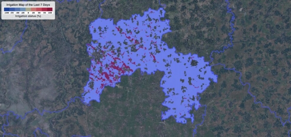
Image: One of the many IRAS outputs that are routinely generated during the dry season at biweekly frequency using NASA data. This image of a region in Bangladesh shows the specific areas where over-irrigation has likely occurred in the two weeks prior to June 4, 2023. Over-irrigation is calculated based on comparison between actual water consumed by crops, which is estimated using Landsat data, and the crop water demand, which is estimated using weather data from GFS. (Credits: Courtesy of Faisal Hossain via NASA)