In January 2024, Tropical Cyclone Belal lashed Réunion and Mauritius, islands in the southwest Indian Ocean east of Madagascar, with torrential rain and flooding.
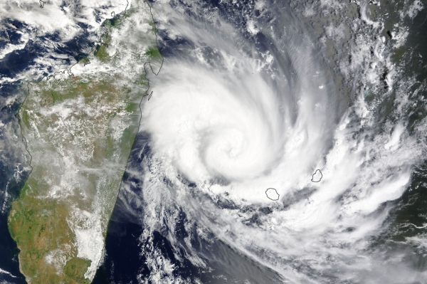
The MODIS (Moderate Resolution Imaging Spectroradiometer) on NASA’s Terra satellite acquired the top image at about 06:00 Universal Time (10 a.m. in Réunion) on January 14. The storm strengthened that day to the equivalent of a category-2 hurricane, with sustained winds of at least 160 kilometers (100 miles) per hour.
Belal made landfall over northwestern Réunion on the morning of January 15 bearing sustained winds near 170 kilometers (105 miles) per hour. Mauritius, located 226 kilometers (140 miles) northeast of the French island of Réunion, was also hit by high winds and heavy rain as Belal’s center passed south of the island nation. According to news reports, authorities in Réunion issued the highest storm alert (purple); officials in Mauritius issued a level three cyclone warning, the second-highest alert of the island’s warning system.
Read more at NASA Earth Observatory
Image: NASA Earth Observatory image by Wanmei Liang, using MODIS data from NASA EOSDIS LANCE and GIBS/Worldview. VIIRS data from NASA EOSDIS LANCE, GIBS/Worldview, and the Joint Polar Satellite System (JPSS).