A large plume of dust from the Sahara Desert blew west over the Atlantic Ocean and then curled north toward Europe in late January 2024. Along its path, the suspended particles brought haze and poor air quality to Cabo Verde and the Canary Islands. Some of the dust that reached the United Kingdom mixed with clouds and fell to the ground with passing rain.
This animation shows the progression of the dust from January 24 to January 28. The images were acquired by the VIIRS (Visible Infrared Imaging Radiometer Suite) sensor on the NOAA-20 satellite. A large dust cloud expanded to the west over the ocean on January 24 and 25 before being redirected by strong southerly winds.
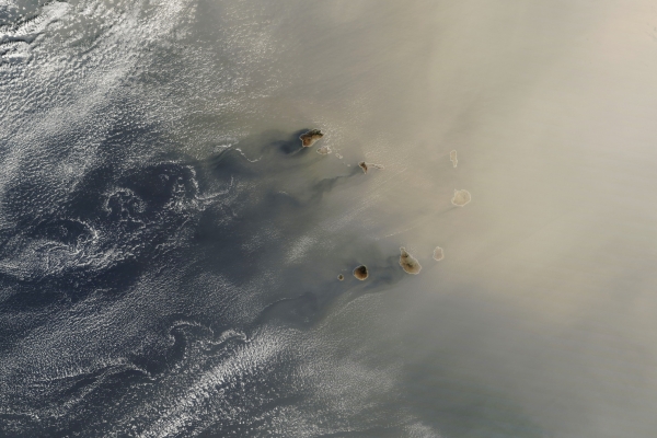
A detailed image from January 25 (below) shows the dense dust cloud reaching the Cabo Verde archipelago, located approximately 550 kilometers (340 miles) off the coast of Africa, west of Dakar, Senegal. The topography of the islands disrupts air flowing past them, producing swirling patterns on their leeward sides. This image was acquired by the MODIS (Moderate Resolution Imaging Spectroradiometer) on NASA’s Terra satellite.
Read more at NASA Earth Observatory
Image: NASA Earth Observatory images by Lauren Dauphin, using VIIRS data from NASA EOSDIS LANCE, GIBS/Worldview, and the Joint Polar Satellite System (JPSS) and MODIS data from NASA EOSDIS LANCE and GIBS/Worldview.


