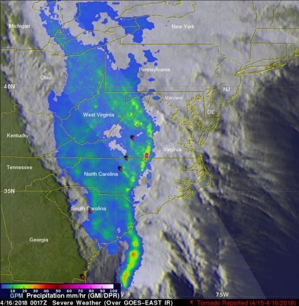
On Sunday April 15th, a line of strong storms at one point stretched from the Florida Straits below the Florida Keys all the way up the East Coast and into Ohio. The Global Precipitation Measurement mission or GPM core satellite analyzed the severe storms as it passed overhead. GPM is a joint mission between NASA and the Japan Aerospace Exploration Agency, JAXA.
Many of the storms were strong with wide spread reports of wind damage from north Florida up through the Carolinas and into central Virginia. Among these were several reports of tornadoes from Florida to Virginia. The most significant were an EF-2 tornado that stuck Greensboro, NC, killing one person, and a tornado near Lynchburg in Amherst County Virginia that injured 8 people.
GPM captured an image of the advancing line of storms on April 16 at 00:17 UTC (8:17 pm EDT, April 15) about one hour after the tornado was reported near Lynchburg, Virginia. The image showed instantaneous surface precipitation rates estimated from the GPM.
GPM revealed that the storms are organized into a classic squall line with a strong relatively narrow leading line of thunderstorms producing heavy rain rates followed by a much broader area of light to moderate. This leading line has a wave-like pattern.
Read more at NASA/Goddard Space Flight Center
Image: GPM captured an image of the advancing line of storms on April 16 at 00:17 UTC (8:17 pm EDT, April 15). GPM showed a narrow leading line of thunderstorms producing heavy rain rates (orange and red areas), followed by a much broader area of light to moderate rain (blue and lighter green areas). (Credit: NASA/JAXA, Hal Pierce)


