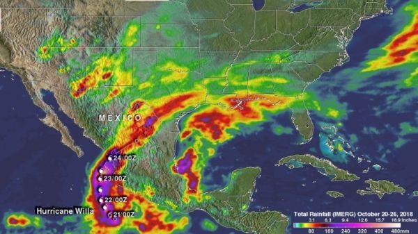
NASA uses satellite data to calculate the amount of rainfall generated from tropical cyclones, and used that capability for the Eastern Pacific Ocean’s Hurricane Willa.
Tropical Depression 24E formed on October 20, 2018 and later in the day became tropical storm Willa. The tropical depression rapidly intensified and was a category five hurricane with winds of over 161 mph (140 knots) on October 22. Willa had weakened to category three intensity when it made landfall in Sinaloa, Mexico on October 24, 2018. Moisture streaming from Willa’s remnants added to the soaking of the already water logged state of Texas. Moisture from Willa’s remnants contributed to storms over the Southeast and to the developing Nor’easter moving over the East Coast.
At NASA’s Goddard Space Flight Center in Greenbelt, Maryland a rainfall accumulation analysis was generated by totaling Integrated Multi-satellitE Retrievals for GPM (IMERG) data for the period from October 20 to 26, 2018. The IMERG rainfall accumulation data indicated that Willa produced rainfall totals greater than 20 inches (508 mm) in the Pacific Ocean off Mexico’s coast. IMERG data also indicated that rainfall accumulations of over 15 inches (381 mm) occurred in parts of Mexico and Southeastern Texas.
Read more at NASA / Goddard Space Flight Center
Image: A rainfall accumulation analysis was generated by totaling Integrated Multi-satellitE Retrievals for GPM (IMERG) data for the period from October 20 to 26, 2018. Hurricane Willa’s approximate 0000Z and 1200Z locations are shown on this analysis. Willa produced rainfall totals greater than 20 inches (508 mm) in the Pacific Ocean off Mexico’s coast. IMERG data also indicated that rainfall accumulations of over 15 inches (381 mm) occurred in parts of Mexico and Southeastern Texas. Credit: NASA / JAXA, Hal Pierce


