NASA’s Aqua satellite passed over the Northwestern Pacific Ocean and looked at comma-shaped Tropical Storm Faxai in infrared light.
At 11 a.m. EDT (1500 UTC), the Joint Typhoon Warning Center or JTWC reported that Tropical Storm Faxai had maximum sustained winds near 55 knots (63 mph/102 kph). JTWC said the storm is intensifying and that is evident by the powerful thunderstorms that NASA’s Aqua satellite found using infrared imagery.
Faxai was located near 24.7 degrees north latitude and 148.1 degrees east longitude, about 371 nautical miles east of Iwo To Island, Japan. Faxai was moving to the west-northwest.
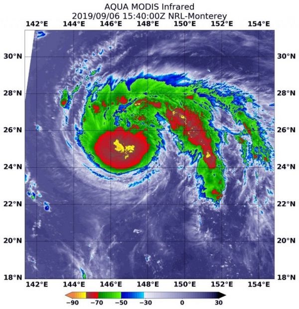
On Sept. 6 at 11:40 a.m. EDT (1540 UTC), the Moderate Imaging Spectroradiometer or MODIS instrument that flies aboard NASA’s Aqua satellite used infrared light to analyze the strength of storms within the storm.
Read more at NASA / Goddard Space Flight Center
Image: On Sept. 6 at 11:40 a.m. EDT (1540 UTC), the MODIS instrument that flies aboard NASA’s Aqua satellite showed the classic comma-shaped Tropical Storm Faxai where the strongest thunderstorms had cloud top temperatures as cold as minus 80 degrees (yellow) Fahrenheit (minus 62.2 Celsius). Credit: NASA/NRL