NASA’s Aqua satellite passed over the Northwestern Pacific Ocean from its orbit in space and took an image that showed vertical wind shear was weakening Faxai and the storm had become extra-tropical.
On Sept. 9, the Joint Typhoon Warning Center or JTWC posted its last advisory on the system as it continues to weaken. At 5 p.m. EDT (2100 UTC), the JTWC stated that Faxai’s center was located near latitude 39.4 degrees north and longitude 147.7 degrees east. That is about 254 nautical miles east-southeast of Misawa, Japan. Faxai was moving to the east-northeast. Maximum sustained winds were near 45 knots (52 mph/83 kph). Faxai had begun its extra-tropical transition as it entered the baroclinic zone over the colder waters.
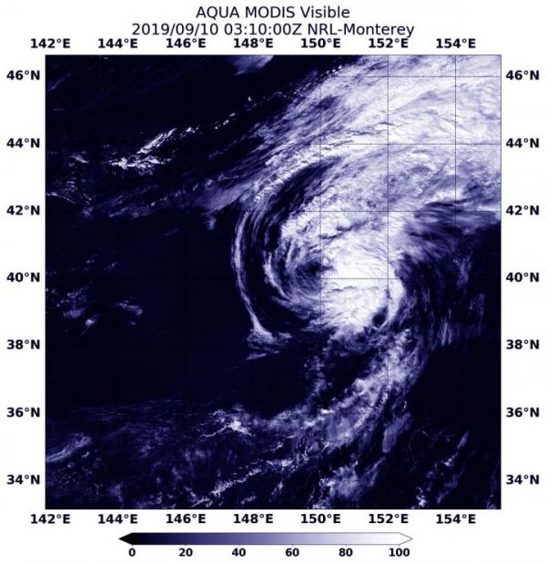
On Sept. 10, 2019 at 0310 UTC (Sept. 9 at 11:10 p.m. EDT) the Moderate Resolution Imaging Spectroradiometer or MODIS instrument aboard NASA’s Aqua satellite provided a visible image of Tropical Storm Faxai that showed wind shear was pushing clouds and storms east of the center.
In general, wind shear is a measure of how the speed and direction of winds change with altitude. Tropical cyclones are like rotating cylinders of winds. Each level needs to be stacked on top each other vertically in order for the storm to maintain strength or intensify. Wind shear occurs when winds at different levels of the atmosphere push against the rotating cylinder of winds, weakening the rotation by pushing it apart at different levels.
Read more at NASA/Goddard Space Flight Center
Image: On Sept. 10, 2019 at 0310 UTC (Sept. 9 at 11:10 p.m. EDT) the MODIS instrument aboard NASA's Aqua satellite provided a visible image of extra-tropical storm Faxai that showed wind shear was pushing clouds and storms east of the center and elongating the storm. (Credit: NASA/NRL)