The Atlantic Ocean’s Gabrielle has made a second transition and the Global Precipitation Measurement mission or GPM core satellite provided information about the rate in which rain was falling within the now extra-tropical storm.
Gabrielle made its first transition to a post-tropical cyclone on Sept. 6 and regained tropical storm status later that same day. Now, the storm has become extra-tropical.
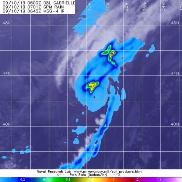
The GPM or Global Precipitation Measurement mission’s core satellite passed over Tropical Storm Gabrielle in the eastern North Atlantic Ocean on Sept. 9 at 3:01 a.m. EDT (0701 UTC). GPM found the heaviest rainfall north of the center where it was falling at a rate of over 25 mm (about 1 inch) per hour. GPM is a joint mission between NASA and the Japan Aerospace Exploration Agency, JAXA.
NOAA’s National Hurricane Center noted at 11 a.m. EDT (1500 UTC) on Sept. 10, “Gabrielle has now completed its transition to an extra-tropical cyclone this morning based on the latest GOES-16 satellite imagery. The center of the storm has now become exposed with convection displaced to the north of the center, and a well-defined baroclinic zone has become established in association with the low center.”
Read more at NASA/Goddard Space Flight Center
Image: The GPM core satellite passed over Post-Tropical Storm Gabrielle in the eastern North Atlantic Ocean on Sept. 9 at 3:01 a.m. EDT (0701 UTC). GPM found the heaviest rainfall (yellow) north of the center where it was falling at a rate of over 25 mm (about 1 inch) per hour. (Credit: NASA/JAXA/NRL)