Satellite data has confirmed that Humberto, once a major hurricane is now a post-tropical cyclone. NASA’s Terra Satellite provided a visible image of Post-Tropical Cyclone Humberto as it continued moving in an easterly direction through the North Atlantic Ocean.
At 11 a.m. EDT on Sept. 19, Humberto was still a powerful hurricane, but the system was in the process of transitioning to an extratropical cyclone. NASA satellite images indicated that frontal features had formed as indicated by its elongated appearance. Cooler and drier air was also wrapping around the western and southern sides of the circulation.
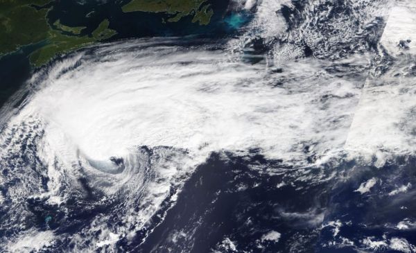
On Sept. 19 at 1:30 p.m. EDT, the Moderate Imaging Spectroradiometer or MODIS instrument that flies aboard NASA’s Terra satellite provided a visible image of Humberto and it was almost a post-tropical cyclone. The image and other satellite images showed a well-defined cold and warm front, but they did not appear to be fully connected to the center of circulation. The MODIS image indicated Humberto was still producing an area of strong thunderstorms northwest of the exposed low-level center.
By 11 p.m. EDT, satellite images showed little strong thunderstorm development, and it was well to the north of the center of the cyclone. Imagery also showed cold air stratocumulus clouds over the western and southern portions. Those cold clouds are indicative of cold air advection (cold air moving in) that is characteristic of an extratropical cyclone. As a result, Humberto was designated post-tropical and the final advisory on the system was issued by the National Hurricane Center.
Read more at NASA Goddard Space Flight Center
Image: On Sept. 19, the MODIS instrument that flies aboard NASA’s Terra provided a visible image of Post-Tropical Cyclone Humberto moving through the North Atlantic Ocean. (Credit: NASA Worldview, Earth Observing System Data and Information System (EOSDIS).)