Imagery from NASA-NOAA’s Suomi NPP satellite found Tropical Storm Lorena lashing the western coast of Mexico.
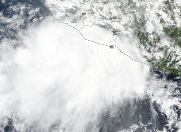
The Visible Infrared Imaging Radiometer Suite (VIIRS) instrument aboard Suomi NPP provided a visible image of Lorena on Sept. 18 that revealed powerful storms circled the low-level center. The image showed strong bands of thunderstorms sweeping over the coast of western Mexico over the western parts of Michoacan and Colima states. Data from NASA’s Aqua satellite revealed that some of the thunderstorms were over 12,000 meters or 7.4 miles high. NASA research has shown storms high in the troposphere can be strong storms that generate heavy rainfall. It was that heavy rainfall that continued to drench the western coast of Mexico.
Microwave and satellite imagery indicated that the center of Lorena moved along the southwestern coast of Mexico overnight and during the morning of Sept. 19.
Lorena did not move much from the coast since the Suomi NPP satellite image was captured. NOAA’s National Hurricane Center or NHC said, at 11 a.m. EDT (1500 UTC) on Sept. 19 the center of Lorena moved offshore just west of Cabo Corrientes and heavy rains and strong winds continue along the southwestern coast of Mexico.
Read more at NASA Goddard Space Flight Center
Image: NASA-NOAA’s Suomi NPP satellite passed over Tropical Storm Lorena on Sept. 18 and revealed powerful storms around the low-level center. Strong storms were also lashing the coast of western Mexico, bringing heavy rainfall. (Credit: NASA Worldview, Earth Observing System Data and Information System (EOSDIS).)