NASA’s Terra Satellite provides a variety of data on tropical cyclones including cloud heights and cloud top temperatures. Terra examined those factors in Tropical Storm Karen in the North Atlantic Ocean and data showed Karen holding onto tropical storm status.
Tropical cyclones are made up of hundreds of thunderstorms. By analyzing the heights of thunderstorms and their cloud top temperatures, forecasters can tell if a storm is strengthening or weakening. The higher the cloud tops, the stronger the uplift in a storm. That rising air helps thunderstorms develop. As storms go higher, it is an indication that the storm is strengthening. Conversely, if over a period of time, satellite data shows cloud tops falling and warming, it is an indication the storm is weakening because there’s not as strong an uplift or rising air in the storm.
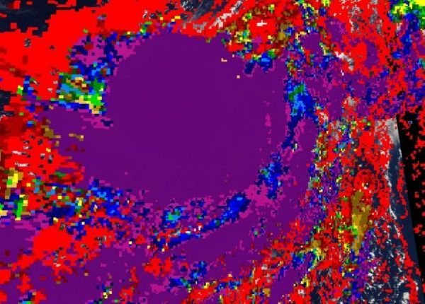
On Sept. 26, the Moderate Imaging Spectroradiometer or MODIS instrument that flies aboard NASA’s Terra satellite measured clouds heights and temperatures. The imagery showed the highest cloud tops, higher than 12,000 meters (7.65 miles) were located around the center of circulation.
Terra data also found that cloud top temperatures were as cold as or colder than 200 Kelvin (minus 99.6 degrees Fahrenheit/minus 73.1 degrees Celsius) in those storms. NASA research has shown that cloud top temperatures that cold have the capability to generate heavy rainfall.
Read more at NASA’s Goddard Space Flight Center
Image: On Sept. 26, the MODIS instrument that flies aboard NASA’s Terra provided an image of cloud top temperatures and heights of Tropical Storm Karen. Purple indicates the highest cloud tops with the coldest temperatures. (Credit: NASA Worldview, Earth Observing System Data and Information System (EOSDIS))