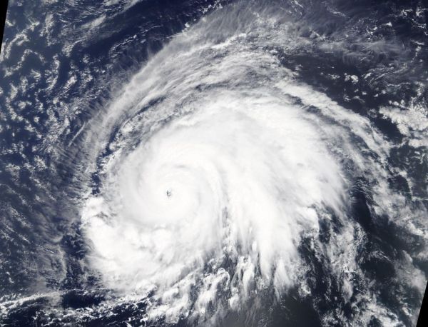
Satellite data has confirmed that Lorenzo is a major hurricane in the eastern North Atlantic Ocean with an impressive structure. NASA’s Terra Satellite provided a visible image of Lorenzo that revealed a clear eye and a solid structure of thunderstorms around the eye.
On Sept. 26, the Moderate Imaging Spectroradiometer or MODIS instrument that flies aboard NASA’s Terra satellite provided a visible image of Lorenzo as a major hurricane. The image and other satellite images showed a well-defined eye. The MODIS image revealed powerful thunderstorms around the eyewall, extending high into the troposphere. The circular shape of the storm indicated an organized and powerful storm.
At 5 a.m. EDT (0900 UTC), on Sept. 27 the center of Hurricane Lorenzo was located near latitude 18.6 degrees north and longitude 42.1 degrees west. Lorenzo is moving toward the north-northwest near 14 mph (22 km/h), and this general motion is forecast to continue today. A turn toward the north is expected on Saturday, followed by a turn toward the northeast on Sunday. Maximum sustained winds remain near 145 mph (230 kph) with higher gusts. Lorenzo is a category 4 hurricane on the Saffir-Simpson Hurricane Wind Scale. Some fluctuations in strength are possible today. Slow weakening is forecast to begin by the weekend.
Read more at NASA’s Goddard Space Flight Center
Image: On Sept. 26, the MODIS instrument that flies aboard NASA's Terra provided a visible image of Hurricane Lorenzo moving through the eastern North Atlantic Ocean. (Credit: NASA Worldview, Earth Observing System Data and Information System (EOSDIS)


