NASA-NOAA’s Suomi NPP satellite passed over the Northern Indian Ocean and provided forecasters at the Joint Typhoon Warning Center with a view of Tropical Cyclone Maha’s eroding structure that helped confirm it is weakening.
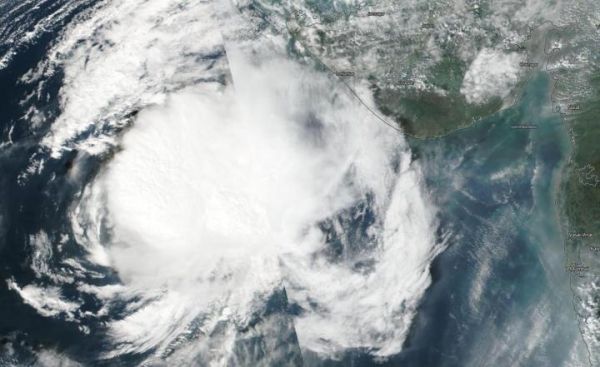
On Nov. 6, 2019, the Visible Infrared Imaging Radiometer Suite (VIIRS) instrument aboard Suomi NPP provided a visible image of Maha that showed it was less circular. Dry air was wrapping into the center of the storm inhibiting thunderstorm development. Maha appeared less circular in the imagery.
The shape of the storm is a clue to forecasters that a storm is either strengthening or weakening. If a storm takes on a more rounded shape it is getting more organized and strengthening. Conversely, if it becomes less rounded or elongated, it is a sign the storm is weakening as Maha is doing.
On Nov. 6 at 4 a.m. EDT (0900 UTC), Tropical Cyclone Maha’s maximum sustained winds were near 50 knots (58 mph/93 kph). It was located near latitude 19.8 degrees north and longitude 66.9 degrees east, about 300 nautical miles south of Karachi, Pakistan.
Read more at NASA/Goddard Space Flight Center
Image: On Nov. 6, 2019, the VIIRS instrument aboard NASA-NOAA's Suomi NPP provided a visible image of Maha that showed it was less circular in shape as it approached the coast of northwestern India. (Credit: NASA/NOAA/NRL)