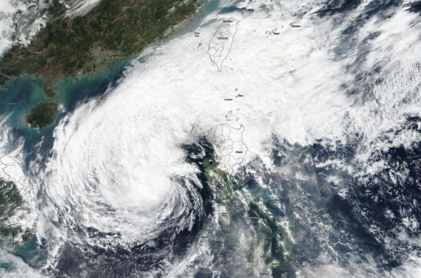
NASA-NOAA’s Suomi NPP satellite passed over the South China Sea and provided forecasters with a visible image of Tropical Storm Kammuri on Dec. 4.
The Visible Infrared Imaging Radiometer Suite (VIIRS) instrument aboard Suomi NPP provided two visible images of Kammuri on Dec. 4 that were combined at NASA’s Goddard Space Flight Center in Greenbelt, Md. to show the entire storm. NASA Worldview, Earth Observing System Data and Information System (EOSDIS) provided the image. The combined VIIRS image showed that Kammuri’s center of circulation was almost in the center of the South China Sea, while a tail of clouds streamed over Luzon, the northern Philippines and north to Taiwan.
Visible imagery from NASA satellites helps forecasters understand if a storm is organizing or weakening by the storm’s shape. NASA-NOAA’s Suomi NPP satellite showed that the storm appears to be elongating, indicating it is weakening.
On Dec. 4 at 10 a.m. EST (1500 UTC), Kammuri’s maximum sustained winds were near 40 knots (46 mph/74 kph) and weakening. Tropical Storm Kammuri (Philippines designation Tisoy) was centered near latitude 14.4 degrees north and longitude 115.7 degrees east. That is about 285 nautical miles west of Manila, Philippines. Kammuri has moved far enough away from the Philippines that all warnings have been dropped.
Read more at NASA/Goddard Space Flight Center
Image: NASA-NOAA’s Suomi NPP satellite provided two visible images of Kammuri on Dec. 4 that were combined at NASA’s Goddard Space Flight Center in Greenbelt, Md. to show the entire storm. The combined VIIRS image showed that Kammuri’s center of circulation was almost in the center of the South China Sea, while a tail of clouds streamed over Luzon, the northern Philippines and north to Taiwan. (Credit: NASA Worldview, Earth Observing System Data and Information System (EOSDIS))


