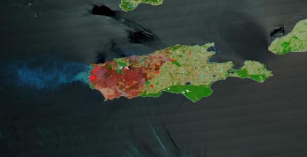
NASA's Terra satellite provided before and after imagery that showed the extent of the fires that have been ravaging Australia's Kangaroo Island. Kangaroo Island lies off the mainland of South Australia, southwest of Adelaide. About a third of the island is made up of protected nature reserves which are home to native wildlife which includes sea lions, koalas and diverse and endangered bird species, including glossy black-cockatoos which have been brought back from the brink of extinction over the last two decades.
In the western part of Kangaroo Island, specifically in Flinders Chase National Park, penguin colonies and famous coastal rock formations are found. Kangaroo Island is Australia's third largest island after Tasmania and Melville Island. In addition to it being a very popular tourist destination for both Australians and nature lovers, the island even boasts a colony of Ligurian honey bees which are the world's only pure-bred and disease-free population of this type of bee.
Which makes the devastating bushfires that have laid waste to almost one-third of the island not only just a major tragedy for the island but an ecological tragedy as well. The bushfires began as lightning strikes within Flinders Chase National Park. Ecologists within the park put estimates of the number of koalas that have perished in the fire at 25,000 which is half the island's population of the popular animals. NASA's fleet of satellites are able to monitor from their various satellites the extent of the damage and the areas continuing to burn which assist firefighters in fighting these major disasters. Below is a slider of two images that show Kangaroo Island both before and after the bushfires.
Read more at NASA/Goddard Space Flight Center
Image: This is a Terra satellite image of Kangaroo Island on Jan. 07, 2020. (Credit: NASA Worldview)


