Formerly a typhoon, Tropical Storm Haishen made landfall in South Korea on Monday, Sept. 2 and continued moving north toward China. NASA’s Aqua satellite provided an infrared view of Haishen as a typhoon before landfall and a visible image after landfall as an extra-tropical storm.
One of the ways NASA researches tropical cyclones is using infrared data that provides temperature information. The AIRS instrument aboard NASA’s Aqua satellite captured a look at those temperatures in Haishen and gave insight into the size of the storm and its rainfall potential.
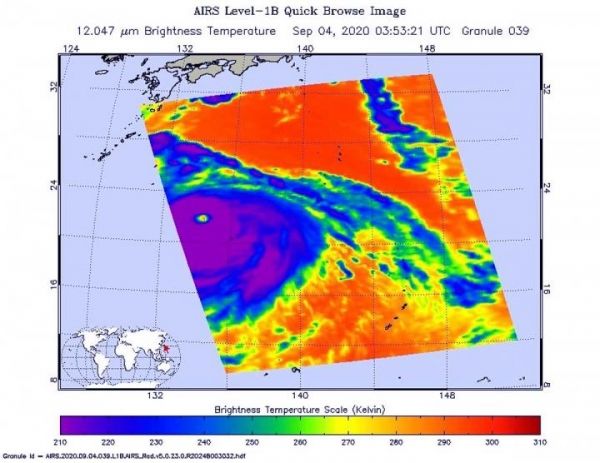
Cloud top temperatures provide information to forecasters about where the strongest storms are located within a tropical cyclone. Tropical cyclones do not always have uniform strength, and some sides have stronger sides than others. The stronger the storms, the higher they extend into the troposphere, and they have the colder cloud temperatures. NASA provides that data to forecasters so they can incorporate in their forecasts.
Read more at: NASA/Goddard Space Flight Center
On Sept. 3 at 11:53 p.m. EDT (Sept. 4 at 0353) NASA's Aqua satellite analyzed Typhoon Haishen using the AIRS found coldest cloud top temperatures as cold as or colder than minus 80 degrees Fahrenheit (minus 62.2 degrees Celsius) around a very clear and open eye.d species with smaller adults have smaller tadpoles. (Photo Credit: NASA JPL/Heidar Thrastarson)