NASA’s Aqua satellite used infrared light to identify strongest storms and coldest cloud top temperatures in Hurricane Teddy as it nears eastern Canada. Teddy has triggered multiple warnings and watches.
Warnings and Watches on Sept. 22
NOAA’s National Hurricane Center noted that a Tropical Storm Warning is in effect for the south coast of Nova Scotia from Digby to Meat Cove, Canada.
A Tropical Storm Watch is in effect from Meat Cove to Tidnish, Nova Scotia, from north of Digby to Fort Lawrence, Nova Scotia. A Watch is also in effect for the Magdalen Islands, Quebec, for Port aux Basques to Francois, Newfoundland and for Prince Edward Island.
Infrared Data Reveals Powerful Storms
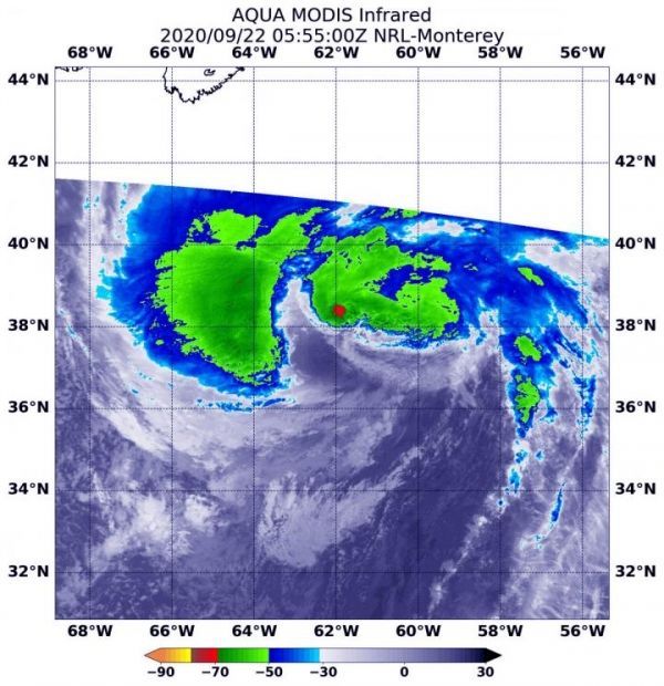
On Sept. 22 at 1:55 a.m. EDT (0555 UTC), the Moderate Resolution Imaging Spectroradiometer or MODIS aboard NASA’s Aqua satellite gathered temperature information about Teddy’s cloud tops. MODIS found the most powerful thunderstorms were in a very small area near the center where temperatures were as cold as or colder than minus 70 degrees Fahrenheit (minus 56.6 Celsius). Most of the rest of the storm had cloud top temperatures as cold as or colder than minus 63 degrees Fahrenheit (minus 53 degrees Celsius). Cloud top temperatures that cold indicate strong storms with the potential to generate heavy rainfall.
Read more at NASA/Goddard Space Flight Center
Image: On Sept. 22 at 1:55 a.m. EDT (0555 UTC), the MODIS instrument aboard NASA's Aqua satellite gathered temperature information about Teddy's cloud tops. MODIS found the most powerful thunderstorms (red) were in a very small area near the center where temperatures were as cold as or colder than minus 70 degrees Fahrenheit (minus 56.6 Celsius). Most of the rest of the storm had cloud top temperatures as cold as or colder than minus 63 degrees Fahrenheit (minus 53 degrees Celsius). (Credit: NASA/NRL)


