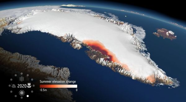
This particular new research, which is based on measurements from ESA’s CryoSat mission, shows that extreme ice melting events in Greenland have become more frequent and more intense over the past 40 years, raising sea levels and the risk of flooding worldwide.
The findings, published this week in Nature Communications, reveal that Greenland’s meltwater runoff has risen by 21% over the past four decades, and has become 60% more erratic from one summer to the next.
Over the past decade alone, 3.5 trillion tonnes of ice have melted from the Greenland ice sheet and spilled into the ocean. This is enough to cover the entire UK with meltwater 15 metres deep or cover the entire city of New York with meltwater 4500 metres deep.
The research was funded by ESA as part of its Polar+ Surface Mass Balance Feasibility project and used measurements from the Agency’s ice mission CryoSat – and it is the first study to use satellite data to detect ice-sheet runoff from space.
Continue reading at European Space Agency
Image via European Space Agency