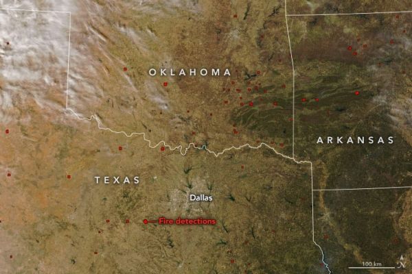
High winds, low humidity, and drought-parched grasses fueled a rash of wildfires in Texas, Oklahoma, and Arkansas in mid-March 2022. According to the Texas A&M Forest Service, at least 178 wildfires have burned more than 108,000 acres across Texas in the past seven days, including one of the largest blazes (by area) in state history. At least three first responders have died in Texas and Oklahoma while responding to the fires.
On March 20, 2022, the Moderate Resolution Imaging Spectroradiometer (MODIS) on NASA’s Aqua satellite acquired images of fires scattered across the Southern Plains of the United States. The natural-color image above is overlaid with red boxes indicating locations where MODIS detected heat signatures indicative of fire. The false-color image below combines visible and shortwave infrared light (MODIS bands 7,2,1). Active fires appear orange; burn scars are brown; unburned vegetation is green; lakes and reservoirs are navy blue; and developed areas are gray.
About 125 miles west of Dallas, the Kidd Fire ignited on March 17 amid days of strong, dry winds. (This short time-lapse sequence shows dust and clouds caught up in the winds.) More than 42,000 acres (65 square miles) have burned so far in a fire that is about 40 percent contained. At least 147 homes and structures have been consumed, including most of the town of Carbon. The Kidd Fire is one of seven that have been grouped into the Eastland Complex by firefighting agencies; more than 54,000 acres (84 square miles) of wildland and property have burned near the town of Eastland.
Continue reading at NASA Earth Observatory
Image via NASA Earth Observatory


