Where are flood waters flowing after major storms? Where are the changes in tree and plant cover after droughts, wildfires, deforestation, or mining? How much did the land move during an earthquake or volcanic eruption? Scientists routinely rely on data-intensive analysis and visualization of satellite observations to track Earth’s ever-changing surface. A new project will make it possible for anyone with an internet connection to begin to answer these questions and more about changes to our dynamic planet.
The OPERA (Observational Products for End-Users from Remote Sensing Analysis) project is managed by NASA’s Jet Propulsion Laboratory, with partners from NASA’s Goddard Space Flight Center, the U.S. Geological Survey (USGS), the University of Maryland, the University of Alaska Fairbanks, and Southern Methodist University. Scientists conceived OPERA in 2020 to address satellite data needs across different federal agencies and to enable better access to information on everything from water management to wildfire monitoring. The goal is to make specific satellite-based observations free and timely for users. The first offerings will be available in April 2023, with more to follow.
“Quite often satellite missions are driven by science, applications, or technology demonstration. In OPERA, we focus on fulfilling the operational needs identified by federal agencies who rely on our work,” said David Bekaert, OPERA project manager based at JPL. “We leverage cloud computing to turn massive amounts of satellite observations into analysis-ready products relevant to our federal stakeholders. Shortening the path from satellite observation to stakeholder decision is a key driver behind the overall implementation and execution of OPERA.”
Read more at NASA
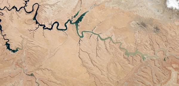
Image: A drought-stricken Lake Powell, the second largest reservoir in the U.S., is captured here in 2014 by the Landsat 8 satellite. Bleached rock along the edges shows the reservoir’s shoreline when at capacity. NASA’s OPERA project brings together multiple space missions to track such water and land changes. (Credits: NASA Earth Observatory image by Robert Simmon using Landsat data from USGS)